
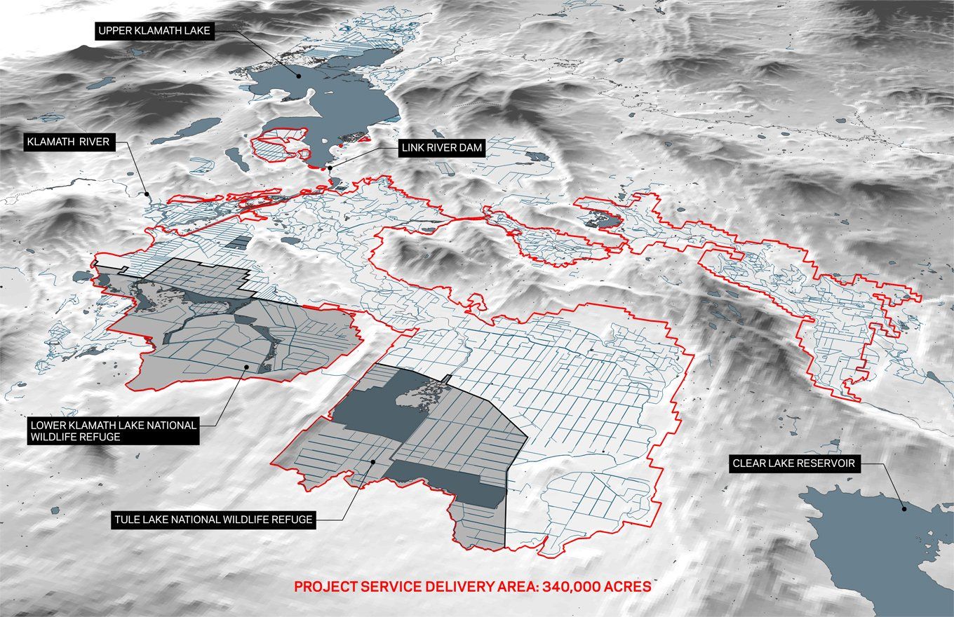
The District
History
The water was here first. It attracted the people.
Before the ditches, before the Project, before the Reclamation Act, this Basin was water — lakes, marshes, and a river that ran in two directions depending on the season. That water is why anyone is here at all.
It drew the Klamath, the Modoc and the Yahooskin, who lived along it for thousands of years, and later the emigrant families who came and stayed. None of them made the water. What they made was the means to move it.
For thirty-four years that was done by hand — by townspeople, by ranchers, and by a widow and her children, digging ditches to carry water onto ground that had been lakebed. Then the United States invested in a Project built at a scale no one here could manage alone. The families of this Basin repaid every dollar of it, from the first shovel to the last payment in 1965.
A ditch can be bought and sold. The right to use the water stayed with the land.
This page is not a chronology. It is the reason a District exists, told through the people who built it and the paper they left behind. Most of what follows can be opened and read for yourself — the contracts, the minute books, the surveys, the letters. Where the record is thin or disputed, this page says so.
The bottom line, before the detail
A history page is an odd thing for an irrigation district to spend time on. Districts move water. But this District keeps finding its own past described in rooms it is not in — usually inaccurately, and usually in a way that ends up costing its patrons. So the record is set out here, with the documents attached, and anyone may check it.
Underneath every date on this page is the same small fact, repeating. A person put water on ground and grew something.
The District's mission is one sentence: to acquire, maintain, assure and deliver an adequate water supply for beneficial use on qualified land within the Klamath Project. Everything below is that sentence happening, in order, for a hundred and twenty years. The people who dug the first ditches are gone. The obligation they signed is still being paid, and the ground is still being farmed by the families who took it on.
Featured · The District's own account
A Brief History of the Klamath Irrigation District
The full story, told in maps and photographs — the Klamath Reclamation Project from the ditches that came before it to the District that runs it today. Compiled by Gene Souza, Executive Director, Klamath Irrigation District, from the historical record. Scroll inside the frame, or open it full screen.
Also from the District
Take the interactive tour
A full-screen, map-driven walk through the District and the Klamath Reclamation Project.
Part one · Before the Project
Time Immemorial – 1905
Before the Project
Two things were here before the Klamath Project, and neither of them was built: the water, and the people. Both have pages of their own, because both deserve more room than a summary.
The water. Ancient Lake Modoc once filled this Basin. What it left behind was called the Everglades of the West — a description the Deputy Director of the U.S. Fish and Wildlife Service repeated to the House Committee on Natural Resources in 2022. Natural barriers kept water from running over the reef at Keno, holding two lakes across more than 182,000 acres of open water and marsh, thirty feet deep in places, which in dry years evaporated upwards of 520,000 acre-feet a year before a single acre was farmed. It is nutrient rich: heavy in phosphorus, nitrogen and algae, poor for drinking and superbly suited to growing plants. Sweet and McBeth described what fed it in 1908 — large bodies of semi-stagnant water full of decaying nutrients — and the soils it laid down are among the most productive in the world, compared in the District's own assessment to the black earth of Ukraine. It also runs dry on a cycle. The tree rings record twenty-one consecutive years below the median in the mid-1600s, four years ending in 1846, five more ending in 1852, and twelve from 1924 to 1935.
The people. The Klamath, the Modoc and the Yahooskin lived along these rivers and marshes for thousands of years. The Applegate Trail was driven through their country in 1846; agreements were made, one of them never ratified; a war followed in 1872 whose first shots were fired on lands this District serves; and not everyone was removed.
The ditches that came first
The first ditch in this Basin was dug in 1868. George Nurse, who had founded Linkville the year before, and Joe Conger planted a garden and set out fruit trees on the east side of Link River — trees that grew into the well-known Conger orchard. Orchards and gardens do not keep themselves alive through a Klamath summer on twelve inches of rain. Water was brought to them, and bringing water to ground is what a ditch is. The Klamath County Historical Society, weighing the same evidence, concluded that “this Nurse-Conger ditch may have been the first”; a Peter Britt photograph of Linkville from 1874 shows a flourishing crop of corn on the ground across the river.
Two later ditches are sometimes given the honour and both deserve their place. The Moore ditch of 1877, almost a thousand feet long, is on record as the first ditch on the river — built to power a sawmill and flume logs down from the upper lake, and taken over by the Reclamation Service as the Keno Canal. And the Linkville Water Ditch Company of 1878 is the first with a corporate existence, a stock certificate and, eventually, an adjudicated priority.
The distinction is worth keeping. The first ditch and the first water right are not the same thing. The Nurse-Conger ditch carries no adjudicated priority — it was never claimed in the Klamath Basin Adjudication. The oldest priority the State awarded on this ground runs from Steele's appropriation of 21 March 1884, and it belongs to this District as Claim 321-9, KA-1004.
Ten years after that, on March 15, 1878, a group of Linkville citizens — Linkville is now Klamath Falls — incorporated the Linkville Water Ditch Company and ran a canal off the head of Link River — heading at the lower reef, the same reef the Link River Dam would later be built on — to water the town lots. Forty miners' inches. One cubic foot per second, tapped at the lower reef. It came to be known as the Ankeny-Henley Canal.
In the spring of 1884 a rancher named William Steele enlarged it and extended it into the Klamath Valley for fifteen miles. For the privilege of enlarging, Voorhees records, Steele gave each member of the old company a certificate for one miner's inch of water — forty inches in all. Steele had come from Ireland by way of Wisconsin and Reno, ranched cattle at Pyramid Lake, and reached this country about 1883 convinced the stockmen were wrong to winter cattle on tule hay alone. Alfalfa was the answer, and alfalfa wanted water. The extension cost him close to $20,000, and in places took condemnation proceedings against ranchers who believed water would ruin them. When Steele died in 1888 the ditch passed to his widow Esther, then to two of her children, one of them S. S. Henley, and then to a new company incorporated as the Klamath Falls Irrigation Company, with Henry Ankeny holding a third interest. Steele left three daughters, and this Basin's irrigation history runs through their marriages: Fannie married J. Frank Adams, who built the Adams canal; Sophie S. married J. T. Henley, and it is her warranty deed that conveyed right-of-way to the United States for one dollar. It was enlarged from time to time until it carried fifty second-feet.
Enlarged, the canal wound southeast along the foothills out of Klamath Falls for about eight miles and then divided. The main branch ran south seven miles along the divide between the Klamath and Lost Rivers, commanding some of the best land in the valley; the east branch continued towards Olene. Its grade fell one to five feet per mile, its bottom narrowing from fifteen feet at the head to four at the tail. Voorhees's assessment is worth keeping: the system could command sixteen thousand acres and probably never irrigated more than four thousand.
Those branches are still in the ground. The Ankeny-Henley itself is the “A” Canal; its main southern branch is the upper portion of today's C Canal, and the eastern branch towards Olene is today's B Canal. The federal Main Canal, when it came, was laid along the same line and divided at the same place.
The Van Brimmer system rested on a secret. Working with a carpenter's spirit level on a tripod — there was no surveyor to be had locally — the brothers and Adams established that Lower Klamath Lake stood twenty-eight feet higher than Tule Lake. That one measurement made gravity irrigation possible across the whole of the lower Lost River country, and they told nobody while they quietly filed on every vacant tract that would serve as a right-of-way. When the scrapers reached Redding in the summer of 1882, the teamster sent to fetch them asked what on earth a cow country wanted with scrapers.
They were not the only ones working. The Van Brimmer Brothers began construction in 1882 and posted their notice of appropriation on 4 September 1883 — the priority date the State of Oregon awarded a century later — to water about four thousand acres on the south and west sides of Lost River near Merrill, drawing from White Lake. It took them four years; the ditch was finished in 1886, carrying water out of the Lower Klamath basin and into the Tule Lake basin.
That same year, J. Frank Adams and his neighbours completed six miles of canal from Lost River to Adams Point — and they did it by agreement with the Van Brimmers, who furnished five thousand inches of water through their system to the west bank of Lost River, where Adams built a wooden flume to carry it across. By 1904 his canal ran twenty-two miles around the north side of Tule Lake as far east as the Carr Ranch, eventually watering some ten thousand acres. It was renamed in 1915. It is the District's D Canal today.
Two private systems, joined by a handshake and a wooden flume, twenty years before the Reclamation Service arrived.
One date is worth settling in public. Reclamation's current website dates the Ankeny Canal to 1887. That is nine years late, and the correction does not depend on state law or on anything this District says — it comes from Reclamation's own project history, written by its Assistant Engineer while the canals were being built.
Voorhees, U.S. Reclamation Service, on the Ankeny-Henley
“In 1878 a number of Linkville citizens incorporated under the name of The Linkville Water Ditch Co. and dug a small ditch heading in Link River about 2 miles above what is now known as Klamath Falls… In the spring of 1884, William Steele enlarged this ditch and extended it into the Klamath Valley for a distance of 15 miles.”
The State of Oregon reached the same conclusion independently. After a full adjudication of the evidence it awarded this District a priority of March 21, 1884 on that canal. Two federal records and one state decree agree; only the modern web page does not.
By 1903, private interests in this Basin had thousands of acres under irrigation without a dollar of federal money in any of it. The figure is worth setting out by its parts rather than as a round number, because the parts are documented and the round numbers are not.
- Ankeny-HenleyAbout 4,000 acres irrigated, on a system that Voorhees reckoned could command 16,000. The United States bought the ditch in 1905 for $50,000 plus a water right for 1,799 acres — the same 1,799 acres the State of Oregon later adjudicated to this District under Claim KA-1004, priority March 21, 1884.
- Adams / Little Klamath Ditch Co.Twenty-two miles of canal by 1904, drawing through the Van Brimmer system under the 1886 agreement, running to the Carr Ranch country and the Lost River. Bought by the United States in 1905 for $100,000.
- Van Brimmer Ditch CompanyConstruction begun 1882, notice of appropriation posted 4 September 1883, finished 1886, drawing from White Lake. About 4,000 acres, carried at 4,500 in Reclamation's 1919 accounting, with a contract entitlement of fifty second-feet.
- Linkville town lotsForty miners' inches from 1878 — small, and the origin of everything above it on this list.
One of those dates was tested and settled. The Van Brimmers posted their notice of appropriation on 4 September 1883, at the point of diversion — and filed it in Siskiyou County, California, believing the diversion lay on that side of the line. On discovering it was in Oregon they filed again on 19 September 1884. When Oregon adjudicated the claim it forgave the error under ORS 539.010(6), which excuses irregularities in pre-1909 notices made in good faith, and awarded the earlier date: 4 September 1883, fifty cubic feet per second, 4,695.1 acres, 15 April to 15 October — Claim 321-6, KA-1001, held by the Van Brimmer Ditch Company to this day.
The United States had claimed the same water on a priority of 1882, asserting that Van Brimmer had transferred the right to it in the 1909 settlement. Oregon denied that claim. The company had given up its riparian rights; it had never conveyed the appropriative right. It is the same finding the State made about the Ankeny, and it is the pattern this whole history turns on: the United States bought ditches, and twice claimed the water that ran in them, and twice the State of Oregon said the water was not the ditch's to sell.
Add them and Reclamation's own figure is the one that holds. Its 1953 accounting puts about 4,000 acres under the Ankeny-Henley on the east bank of Link River and about 9,000 under the ditches running from Lower Klamath Lake toward the Lost River near Merrill — the Adams and Van Brimmer systems together. Its published history states the total plainly: approximately 13,000 acres irrigated by private interests by 1903.
The District has elsewhere used a figure nearer 21,000. That number appears to measure something different — land these systems could command rather than land they actually watered, which for the Ankeny-Henley alone was a gap of four thousand against sixteen. This page uses 13,000 for acreage irrigated, because it is the federal government's own figure, it is traceable to its parts, and it cannot be argued down. Land commanded and not yet watered was substantially greater, and that is a separate claim which should be made separately.
“The Klamath Project incorporated several privately built canals…”
Reclamation did not come here to build irrigation. It came to enlarge it.
And then the government came to look
All of that was in the ground before any federal engineer set eyes on it — and when one finally did, he wrote down what he found. Before Whistler came in November 1903, another engineer had already been through. H. E. Green left Bieber on 13 October 1903 and rode north through Lookout, Craig and Dry Lake, past Cornell and the Jesse D. Carr ranch, around the north side of Tule Lake to Merrill, then south to Willow Creek and west to Ball. His Report of Reconnaissance of the Country Lying on Either Side of the Boundary Line Between California and Oregon survives in the District's vault, typed on onion skin.
It is the earliest federal description of this ground the District holds, and four things in it are worth having.
- The river, measured“The Klamath River was measured by meter at the railroad bridge at Klamathon, at its lowest stage of this year (reported by residents to be lower than it has been for several years), and was found to be discharging 2,000 second-feet.” A gauged low-water figure for the Klamath in the autumn of 1903, taken before any of the works existed.
- The Ankeny ditch, before the United States bought itGreen crossed it on the county road and found it “not in very good shape” — about twelve square feet of cross-section, discharging six hundred miner's inches or more, watering the ground between Klamath Falls and Lost River. He notes that carrying water at a higher level had been costed at around $700,000, that without a dam only three or four feet of elevation could be gained, and that “nearly all the land tributary to such a canal is in private ownership.”
- J. Frank Adams, already at work“There is also an irrigating project being carried out from Lower Klamath Lake, which is in the hands of a company, and the work being carried out is in charge of Mr. J. F. Adams, of Merrill.” Two years before he signed Trust Deed No. 1, Adams was the man a federal engineer named as running the Lower Klamath works.
- The scale of what was possibleLink River falls sixty to seventy feet in a mile and was already being used for power. Clear Lake he computed at 460,800 acre-feet behind a thirty-foot working head — and found that Jesse D. Carr had already dammed Willow Creek to turn its water into Lost River and flood his hay ground. Of the canyon country he wrote that fifty to a hundred thousand acres might be irrigated, “a very well-known project… discussed by many engineers, but no detail work has ever been done.”
Green's closing sentence is about grass. Passing Steele Swamp he counted twenty-four haystacks of perhaps a hundred tons each from the wagon road, and ended his report calling it “an illustration of what could be done with even the native grass when assisted by water applied under control.”
Part two · Building it
1902 – 1905
The Reclamation Act, and the Association
Congress passed the Reclamation Act on 17 June 1902, and with it a method: the United States would advance the capital to build irrigation works in the arid West, and the landowners who benefited would pay it back. Nothing was granted. Everything was lent.
For that to work here, somebody had to be liable. In the winter of 1904 the Chief Engineer of the Reclamation Service came to Klamath Falls and told a large audience what the Project would cost them — twenty dollars an acre, and only up to the point at which it was turned over to the water users. On 4 March 1905 the landowners incorporated the Klamath Water Users Association to accept that liability; on 1 April, at Houston's Opera House, they raised its capital stock to three million dollars and adopted By-Laws whose Article I named the territory “the Klamath Irrigation District” — twelve years before the District existed.
Congress had already cleared the ground. An Act of 9 February 1905 authorised the raising and lowering of Lower Klamath and Tule Lakes for a federal project, and Oregon and California ceded their rights in those lakebeds the same year. The Secretary authorised construction on 15 May 1905 for $4.4 million.
On 3 November 1905 the stockholders met at the Courthouse and directed their Board to sign. The contract with the United States is dated 6 November 1905. Three hundred men had guaranteed the cost of a Project that did not yet exist.
1906 – 1916
Building the Main Division — K.I.D. becomes a mega-district
The Project came together canal by canal over three decades. Work on the “A” Canal began in March 1906, with the B, E and F Canals started the same year and the First Unit Main Drain installed. By 1907 the “A” and B Canals had been carried to Olene, thirty-three miles of laterals and drains were finished, and works existed to serve 20,500 acres — of which 8,900 actually took water that year.
The promise the Association had incorporated on came due in 1908, when the Secretary announced a construction charge of $30.00 an acre for the Main Division. The Klamath Water Users Association passed a resolution denying any obligation to pay more than the originally estimated maximum of $20.00 an acre — the figure Newell had given them in 1904. Secretary Garfield's response, as one of his last acts in office, was to suspend construction on the Klamath Project in January 1909. The Association retracted the resolution. His successor, Richard Ballinger, ordered the work resumed.
1909 — The ceiling breaks
Reclamation's Public Notice of 18 November 1908 set the building charge at $30.00 an acre — half again the figure Newell had promised in 1904. The Association resolved that it owed no more than twenty. Secretary Garfield suspended construction. The Association retracted, in a resolution of 23 February 1909 introduced by founding director O. A. Stearns, acknowledging that its contract and every shareholder's stock subscription were binding and that “nothing the Board of Directors could do or fail to do would relieve either the shareholders or the Water Users' Association from the provisions of the contracts.” Secretary Ballinger ordered the work resumed. By 1913 the stockholders were telling the Secretary that their payments had been “largely derived from sources other than the produce of the soil” — that they had exhausted their credit beyond what the farms could earn. They were paying with money the ground had not made.
The C Canal followed in 1908 and 1909, including 4,300 feet of flume. By the end of 1909 there were 23.5 miles of main canal and 47 miles of laterals, and roughly 21,620 acres taking Project water. Contracts for the Lost River Diversion Channel and the Lost River Diversion Dam were let in 1910 and both were completed by 1912. In 1913, local farmers working under the direction of the Reclamation Service began expanding the D Canal — the one Frank Adams and his neighbours had dug by hand in 1886.
Reclamation settled the question itself in 1953: by 1912, 23,034 acres were irrigated in what was later called the Main Division, and nearly all the initial distribution system was complete.
The year-by-year record is in the Reclamation Service's own history of the Project for 1903 to 1912, written by Assistant Engineer I. S. Voorhees. By the 1909 season the Service was prepared to furnish water to 30,000 acres, and about 21,000 were irrigated. In 1910 the area rose to 23,000. In 1911 and 1912 it stood at 24,000 acres. The East Branch reached Olene in the spring of 1912, and the Second Unit laterals were taken up from there.
In 1868, George Nurse and Joseph Conger dug a ditch off the east side of Link River to water their gardens. Thirty-four years would pass before Congress passed the Reclamation Act. That ditch later became part of the Ankeny Canal.
What was actually built — and what it was built on top of
A contract for the “A” Canal was awarded in December 1905 and work began in March 1906. When Reclamation's contractor reached a three-mile stretch, it could not finish: the route ran along the Ankeny-Henley Canal, then in operation. The Project's main canal follows the line the Basin dug by hand.
The canal itself came across the following year. In July 1906, the Klamath Falls Irrigation Company — successor to Steele, to his widow Esther, and to S. S. Henley — deeded the Ankeny-Henley Canal to the United States. That deed is the one the State of Oregon would examine ninety years later, and it is the reason the acreage figure in the District's water right is what it is.
On May 22, 1907, water was turned into the “A” Canal — routed, because the new headworks were not yet finished, through the old Ankeny ditch. It was the first delivery of water through Klamath Project works, and it ran down a channel dug by private hands twenty-three years earlier. Division 1, with its headworks and tunnel, was formally put in commission on June 27.
The shape of it is worth knowing, because almost none of it was new country. The Main Canal heads where Link River leaves Upper Klamath Lake and runs southeast for nine miles at a capacity falling from 1,500 to 1,400 second-feet. At the South Branch heading it divides: the South Branch Canal south at 300 second-feet, and a smaller continuation — originally called the East Branch — running four and a half miles east to Olene at 261 second-feet.
For three of those first nine miles the Main Canal was laid on the line of somebody else's ditch. Voorhees records that between mile post 2 and mile post 5 the location was “practically identical with that of the Ankeny Canal, then in service irrigating about 5,000 acres” — so the contractor was barred from working that stretch during the irrigation season, and the Schedule 2 excavation could not be touched at all while the old canal ran. The United States built its Main Canal around a private canal that was still delivering water, and waited on that canal's season to do it.
It had bought the right to do so. The Board settled terms in 1905 with the owners of each system in turn: the Little Klamath Ditch Company — the Adams canal — for $100,000; the Jesse D. Carr Land & Livestock Company for $187,500; and the Ankeny-Henley Ditch for $50,000 plus a water right for 1,799 acres. That acreage is not a coincidence. It is the same 1,799 acres the State of Oregon adjudicated to this District a century later under Claim KA-1004.
Annual Project History, Klamath Project, 1903–1912, Bureau of Reclamation
“…they agreed with J. Frank Adams for the purchase of the property of the ‘Little Klamath Ditch Co.' for $100,000, and with the owners of the Ankeny-Henley Ditch for $50,000 plus a water right for 1799 acres of land…”
This is settled. The source usually cited here as “Voorhees” is Reclamation's own annual Project History for 1903–1912 — the government's contemporaneous record, not a later account — and it gives the figure exactly. Other numbers circulate: Driscoll gives $47,530 for the Ankeny Canal, and Klamath Echoes No. 7 reports a $150,000 settlement after litigation, which appears to describe the separate Klamath Canal Company transaction — the annual history records that the Board of Engineers recommended $150,000 be offered to the Klamath Canal Co. to avoid litigation and delay. Two different purchases, two different figures, conflated in the retelling.
The Griffith question has an answer too, and it is a good one. Koppen, describing the “G” Canal in 1919: “The present ‘G’ Canal is an enlargement of the old Griffiths lateral.” The Griffiths lateral was not absorbed or abandoned. It was widened, and it is still carrying water under a federal letter.
The South Branch Canal was advertised on February 1, 1908 and runs 13.2 miles from Station 481 on the Main Canal to a point a mile northwest of Merrill — where it connects with the old Adams Canal at the Lost River flume crossing. The same pattern again: new federal canal, joined to a private one built twenty-two years earlier. Its distribution system was deliberately built by force account in small schedules, so that local contractors and farmers could bid the work themselves.
What the government told the landowners in 1908
Three years into construction, the Bureau of Soils published its survey of the Klamath Reclamation Project. It explained to prospective settlers what the water would cost and on what terms. The sentence is worth reading slowly:
Sweet and McBeth, Soil Survey of the Klamath Reclamation Project, 1908
“It is not yet known what the cost will be, but when determined it will be paid by the owners of the land in ten annual payments, after which the system will become the property of the landowners and the cost of water will be the amount necessary to pay the maintenance and operating expenses of the system.”
That is the United States, in a federal publication, in 1908, describing the arrangement in the plainest possible terms: the landowners pay for the works, and then the works are theirs. The same page records the other side of the bargain — that no holding receiving water could exceed 160 acres, and that any excess had to be sold or turned over to the Government.
The landowners kept their side. The payments were made and the debt cleared on 4 May 1965. The system has not become their property.
And the argument reorganised the Project
The fight over the thirty dollars did not end in a compromise on price. It ended with a Secretary of the Interior drawing a line around the ground he thought too expensive to serve. On 17 February 1910 Ballinger wrote to the Association's Secretary excluding Langell and Yonna valleys — the Upper Project — together with the elevated tracts that could only be watered by pumping, releasing them from their stock subscriptions and from the liens on them.
Reclamation remained willing to serve them if some arrangement could be made to secure the construction charges. That arrangement was the Warren Act of 1911, and it is where the Project's contract classes come from.
The pumping division
The Main Division was designed to run downhill. Water enters at Link River, where the lake surface stands about fifty-five feet above Lake Ewauna, and every acre the original canals were laid out to serve could be reached by gravity. Stoutemyer and Dent put it flatly in 1924: the Klamath Irrigation District, they wrote, “is irrigated entirely by gravity and would have no use for power in connection with its irrigation system.”
That was not true of the rest of the Project. The smaller districts — Enterprise, Pine Grove, Sunnyside and Horsefly — could only be served by lifting water, and it is for them that the 1917 Copco contract carried its unusual clause: power for irrigation pumping, anywhere within twenty-five miles of Merrill, at seven mills per kilowatt hour. The districts that needed pumps got the cheap power, and in 1924 the government's own counsel thought the rate so low that no district would rationally build its own generation instead.
“Pumping division” is not District shorthand. It is Reclamation's own term. The Bureau's 1936 booklet on the Klamath Federal Reclamation Project describes water being diverted from the east side of Link River into the “A” Canal — several hundred feet below the lake and a few hundred feet above Link River Dam — and carrying “water for all lands in the main and pumping divisions” as well as part of the Tule Lake division. One headworks, three divisions, one canal.
The pumping districts have a date, and it is February 27, 1917. On that day a board of engineers — D. C. Henny as consulting engineer, D. W. Cole as senior engineer, and Project Manager J. G. Camp — reported on the Project and recommended that units proposing to pump from the Project canals be charged $15.00 an acre for works already built, on top of the cost of any enlargement needed to serve them. The Department approved it. A further dollar an acre was added for units discharging waste and seepage into the Project drains. Reclamation's 1953 accounting records that the first of five contracts was signed with those districts in 1917, and that more perimeter land came in the same way over the following twenty-five years.
Two years later, in March 1919, Assistant Engineer E. C. Koppen set out the whole scheme. Sixteen pumping units were contemplated, covering 23,610 acres, every one of them lifting off a Project canal: Enterprise at a seventy-foot lift, Pine Grove at thirty, Stukel Mountain, Sand Hollow — which by then had reorganized as Shasta View — Bloody Point, Manning Ridge, White Lake, Miller Hill and South Miller Hill, Spring Lake, North and South Poe, Nuss Lake. Only 4,100 of those acres drew from the Main and “B” Canals; the other 19,510 came off the rest. Enterprise and Pine Grove needed no enlargement at all, so their charge was the flat sixteen dollars.
The pumping districts are not separate systems. They are lifts off this District's canals, and have been since before most of them were formally organized.
Koppen also recorded what the water was doing on the ground. Deliveries to farms on the Klamath Project ran 1.26 acre-feet per acre in 1914, 1.13 in 1915, 1.02 in 1916 and 0.975 in 1917 — falling year on year as the system tightened.
That is the moment this District stopped being one system among several and became the system the others hang from. The first of the five contracts was with Enterprise, and it set the pattern: a separate district, with its own boundary, its own board and its own assessment, taking its water through Klamath Irrigation District works and paying a share of what those works had cost. Pine Grove followed on the same terms. Fourteen more units were contemplated behind them.
Every arrangement that came afterwards was built on that shape. The Warren Act contractors, the districts formed later, the individual landowners with their own contracts — all of them reach their water down canals this District operates. By the time the 1954 contract transferred the care, operation and maintenance of the Transferred Works, it was not handing over a district's own plumbing. It was handing over the artery of the Project's Oregon side, and the responsibility for everyone drawing off it.
That is what makes the title question consequential rather than administrative. The body that would take title is already the body that operates the works, maintains them out of its patrons' assessments, and carries the obligation to everybody the works serve. The responsibility transferred in 1955. Only the deed did not.
The District's own pumped lands came later. Under Article 4 of the 1954 contract the United States transferred to this District, along with the canals and drains, the Adams and Miller Hill pumping plants — and the District has operated, maintained and paid for them ever since, out of the same assessments that carry the gravity system.
What the gravity system became, in the end, is the artery for a good deal more than this District. Water reaches the Enterprise, Pine Grove, Sunnyside, Malin and Shasta View districts, the Klamath Basin Improvement District, the Van Brimmer Ditch Company and roughly a hundred individual Warren Act contractors through Klamath Irrigation District works — carried, in most cases, down canals the District operates and maintains at its own patrons' expense. When this District is shut off, they are shut off with it.
So the Main Division was built and delivering within five or six years of the first shovel. What came afterwards was extension rather than construction — the Second Unit laterals from 1912, and in 1913 local farmers, working under the Reclamation Service, expanding the old Adams canal into today's D Canal. The rest of the Klamath Project went on being built for another twenty-eight years. The part this District operates was finished in five, and the District has run it ever since.
Congress changed the terms of the work in 1911. The Warren Act authorized the United States to contract for the delivery of surplus Project water to lands outside a project's boundaries — and Warren Act contracts entered in this Basin are still in force. They are also a recurring source of confusion, because a contract can carry its own order of delivery, and that is a different thing from a water right priority under Oregon law. The State of Oregon has determined which one governs.
Read the annotated Warren Act of 1911 page — what each contract actually promises, how a delivery contract differs from a settlement, and what the State of Oregon determined about all of them.
1917 – 1922
The District, and the dam
Oregon passed the enabling law in November 1917, allowing irrigation districts to take on contracts with the federal government. The Association's directors put the question to a vote, and the Klamath Irrigation District was created, encompassing 68,652 acres — established, in the words of its own bylaws, by an “Order Declaring Result of Election” entered in the Circuit Court of the State of Oregon for the County of Klamath. The District began work on 18 December 1917, the day its directors qualified and organized. The following day, three of the Association's own board members — G. W. Offield as chair, J. M. Ezell and A. L. Marshall — were elected its first directors, with Albert E. Elder as secretary. The same men, the same ground, a new legal body built for one purpose: to carry the 1905 contract. On July 6, 1918, Contract Ilr-173 carried the repayment obligation from the Association to the District. Same families, same debt, new name on the paperwork.
The first minute of the Klamath Irrigation District records what happened next, and it is worth reading closely. On 18 December 1917 the directors-elect — G. W. Offield, J. M. Ezell and A. L. Marshall — filed bonds of five thousand dollars each with the County Clerk, approved beforehand by the County Court; took and subscribed the oath of office; filed that too; and then met at three o'clock that afternoon in the office of Albert E. Elder in Klamath Falls and proceeded to organize. Offield took the chair and was elected President. Elder was elected Secretary.
They then transacted three items of business. Two were bills: forty-five dollars to Arthur Wilson for the directors' bonds, and $1,010.75 to the Klamath Record for publishing the petition, the notice of organization and the notice of election, and for the poll books and election supplies. The third was this:
Minutes of the Board of Directors, Klamath Irrigation District, 18 December 1917
“The Secretary was authorized to take up with the Interior Department the question of securing a contract with said department looking to the assumption by the district of federal charges against district lands.”
That is the first substantive act of this District, taken within hours of its directors being sworn: instructing its Secretary to go to Washington and take on the debt. Contract Ilr-173 followed seven months later. The Board then adjourned to meet again on 2 January 1918.
What the District is
Klamath Irrigation District is a unit of local government. Not a company, not a federal contractor, not a utility. It is a municipal corporation formed under Oregon's Irrigation District Law and governed by ORS Chapter 545 and its own adopted bylaws — the same body of law that governs a port district or a school district. It has no shareholders and pays no dividends. Nobody takes a margin.
Boundary, acreage and account figures from the District's Water Management and Conservation Plan; supply and delivery from its Appendix A.
Its Board is five members, one elected from each of the District's five divisions. Its revenue is assessments levied on the land served, and all of it goes back into the works. The vote attaches to land, not to residence, and it is weighted by acreage — which is what an irrigation district is, and why it is not a city.
Three instruments define what it may do and must do: ORS Chapter 545; Contract Ilr-173 of 6 July 1918, which took over the Association's 1905 contract and made this District the party the United States deals with; and Contract 14-06-200-3784, effective 1 January 1955, which transferred the care, operation and maintenance of the works and set out how title would follow.
None of that makes the District a party to a transaction. It is not a customer buying water from the United States, and it is not a vendor delivering water for a fee. It is the legal successor to the Association the landowners incorporated in 1905 to build this Project and pay for it — carrying the same obligation, to the same ground, under a different name.
The election
The vote that created this District was reported on the front page of the Evening Herald on Tuesday 11 December 1917, under the headline “Klamath Irrigation District Is Formed.”
The Evening Herald, Klamath Falls — official newspaper of Klamath County — 11 December 1917
“With a total opposition of five votes out of 169 cast at the election Saturday, the Klamath Water Users voted to change from a water users association to the Klamath Irrigation District, taking advantage of laws recently passed in the state legislature, and following the example of a large per cent of water users on other reclamation projects… The results of the election were announced this morning.”
So the sequence is now complete. The election was held on Saturday 8 December 1917; the Circuit Court entered its order on Monday the 10th; the result was published on Tuesday the 11th; and the three directors qualified, were sworn, and organised in Albert E. Elder's office on Tuesday the 18th.
One hundred and sixty-four votes for, five against. Twelve years after the Association was carried 8,598 to nothing, its successor was created by almost the same margin.
And why they did it — the reason is not what you would guess
The paper sets out the case the Reclamation Service itself was making for the change, and the second reason is the one that matters:
- Everyone paysUnder a district, “all lands included in a project are forced to bear a part of the expenses, thus forcing development and reducing speculative investment.” No more sitting on dry ground waiting for the value to rise.
- And the farmers could borrow againFarmers would “be able to take advantage of the federal loan system, impossible now because their lands are held by a first mortgage to the government until the water rights are paid.”
That is the whole story of the liens, told from the other end. Every subscription to the Association was a first mortgage running to the United States, and for as long as it stood, no shareholder in this Basin could raise a federal farm loan against his own land. Forming the District was how they got out from under it — which is why Article 2 of Contract Ilr-173, signed seven months later, required those liens to be “discharged of record,” and why the Releases of Lien of 1919 exist at all.
And what Washington was being asked for that same week
Five days after the election, the Ashland Tidings printed a telegram that Representative N. J. Sinnott had sent to the Klamath Falls Commercial Club. It sets the scale of what the District was taking on.
Representative Sinnott to the Klamath Falls Commercial Club, Ashland Tidings, 13 December 1917
“Estimates of the reclamation service and recommendations to congress for the fiscal year beginning next June for the Klamath project are $423,000. This is an increase of $184,000 over the appropriation this year. I shall make every effort to have congress approve these estimates.
Estimates have also been made for $200,000 for the purchase of live stock, homes, barns and agricultural equipment on the Klamath reservation. Will try to have this increased.”
The second paragraph is worth reading as carefully as the first. In the same message, in the same week, this Basin's congressman was pressing for construction money for the Project and for a programme — begun by Edward B. Ashurst and others — to give each family on the Klamath Reservation in reduced circumstances ten head of cattle and a year's maintenance.
Four hundred and twenty-three thousand dollars for the Project; two hundred thousand for the Reservation. Both requests travelled to Washington in the same telegram, in the week this District was formed.
Two names from the District's story appear elsewhere in the same issue. P. L. Fountain — the Association's founding Vice-President — and Wm. M. Cheyne were both sitting on a Circuit Court jury that week. And that evening Albert E. Elder, in whose office the District would organise seven days later, was elected secretary of Klamath Lodge No. 77.
Part three · Conflict, and the transfer
1923 – 1953
Transfer recommended at an early date
In February 1924 the District Counsel of the Reclamation Service, having spent a fortnight in Klamath Falls investigating a petition against this District's Board, reported to the Secretary of the Interior that encouragement should be extended to Klamath Irrigation District to assume the operation and maintenance of the Main Division — and that steps toward it “should be taken at an early date.”
That is the first recorded federal recommendation that this District take over the works it had paid for. The contract was signed thirty-one years later.
And the District did not wait to be asked twice
Thirteen months later, on 31 March 1925, the Board of Klamath Irrigation District sent its own draft contract to R. J. Coffee, District Counsel of the Reclamation Service at Berkeley. The covering letter, over the signature of Secretary A. M. Thomas, is four sentences long:
Klamath Irrigation District to the District Counsel, U.S. Reclamation Service, 31 March 1925
“I am instructed by the Board of Directors of the Klamath Irrigation District to hand you herewith the Board's draft of a contract which they would be willing to accept and put in operation when the Project lands, buildings, tools and the like, embraced in the District, are turned over to the District… If you will, pursuant to our arrangement when you were here, exchange with us by letting us have a copy or copies of your draft, we will consider it a favor.”
They did not wait for the government to write it. They wrote it themselves and asked to trade drafts. It runs to eleven pages and twenty-five articles, and it is recognisably the contract that was signed twenty-nine years later — the District taking over the main canal, laterals, distribution and drainage systems at its own cost; assessing and collecting under Oregon law; keeping records of water deliveries and crops; free access to the project books both ways.
Four things in it are worth reading now.
- The District is named successor to the AssociationThe recitals describe the District as “the successor in title and interest, entitled to all the rights and properties belonging to or which belonged to the Klamath Water User's Association at any time prior hereto.”
- Turnover is stated as the end of the arrangementArticle 19: the contract “shall remain in effect until the project is turned over to this organization, which, according to law, is ultimately to succeed to the interests of the United States.” Not a hope. A term of the draft.
- The twenty dollars, againArticle 25 calls for a new allocation of costs “in accordance with the original contract with the Klamath Water Users' Association, November 3, 1905… which contemplated a construction cost of $20.00.” Twenty-one years after Newell said it, the District was still drafting it into federal contracts.
- Irrigation before powerAll lands in the original Project “shall have the first right to and call upon the waters of Upper Klamath Lake and its tributaries before the same is used for power or other purposes than irrigation” — drafted two years after the Ankeny and Keno canals went to the power company. And the Secretary was to agree a minimum lake level of 4,140 feet.
Twelve existing contracts were listed for the District to assume — Pine Grove, Enterprise, Sunnyside, Malin, Shasta View, Van Brimmer, Klamath Drainage District, Upper Van Brimmer, and two with J. W. Siemens. That list is the ancestor of Exhibit “A” to the 1954 contract. The District was already proposing, in 1925, to carry the districts it still carries today.
What filled the rest of those thirty-one years was negotiation. The obstacle was never whether the District could run the system — Reclamation's own counsel had said in 1924 that it should — but on what terms, at what cost, and with what happening to title. Two years' operation and maintenance could not be paid in one, so a mechanism had to be found; other districts and individuals took water through the same works and their positions had to be protected; the reserved works, which the United States meant to keep operating, had to be separated from the transferred works, which it did not. Stoutemyer and Dent had foreseen all of it in 1924 and declined to work it out: “We do not consider it advisable to enter at this time into a discussion of the details which this would involve.”
The Association had already gone. Its meetings were curtailed shortly after its contracts passed to the District in 1918, and on 6 April 1929 it appointed a secretary to wind up its unfinished business. The body that had guaranteed the Project ceased to exist twenty-six years before the works were handed over.
What came out of the negotiations, in the end, was not just an operations contract. It was a procedure. Contract 14-06-200-3784 transferred the care, operation and maintenance of the works — and then set out, in Articles 4, 5 and 35, exactly how title would follow and how the arrangement would end. The District has been performing that procedure ever since.
A second dispute ran through the same years and is often confused with this one: the sale of the Ankeny and Keno canals to the power company, which the districts fought and delayed for four years. It belongs with the dams and is told there — Keno, the reefs and the dam and Link River, the reef and the dam.
On the Association and its wind-up, see The Klamath Water Users Association of 1905.
1954 – 1965
Transfer, and paid in full
Contract 14-06-200-3784, effective January 1, 1955, handed this District the care, operation and maintenance of the Transferred Works — the “A” through “G” Canals, the C-G Cutoff, the drainage system, the structures and the Adams and Miller Hill pumping plants. Article 4 says title remains in the United States, “except as provided in Article 5”; Article 5 says title shall vest in the District whenever and to the extent the law allows. Article 35 sets out how the arrangement ends.
Reclamation's own counsel had recommended exactly this thirty-one years earlier. In February 1924, District Counsel Stoutemyer and Dent reported to the Secretary that encouragement should be extended to Klamath Irrigation District to assume the operation and maintenance of the Main Division, and that steps towards it should be taken at an early date.
What actually changed hands
The contract was signed on 29 November 1954. The works changed hands on 31 December 1954, and the Regional Director's accounting of 2 February 1955 shows what the transfer consisted of in practice.
- $24,239.05Unexpended balance of the District's own advanced operation and maintenance funds, refundable to its reserve account under Article 24.
- $9,102.59Book value of unused materials and supplies bought with those advances.
- $7,463.26Undepreciated value of equipment bought with them.
- $12,756.82Credit due from the other water users, to be set against sums owed the District for services it would now perform for them.
Every dollar of it was the districts' own money coming back. And the last line describes what this District had just become. Reclamation's own project manager put it plainly in a memorandum that March, explaining why so much copying was needed:
Project Manager to Regional Director, 9 March 1955
“…the complex operating and financial relationships which result from the Klamath Irrigation District becoming not only a distributor of water to its own landowners but also the agent of the Bureau in carrying water to other districts and to individual contractors outside of its boundaries.”
The schedules attached to that file name them one by one — roughly a hundred individual Warren Act contractors by contract number and acreage, from Ilr-143 to 18r-1088, and dozens of water-rental holders including the Oregon Game Commission. From the first day of 1955 this District has carried water for people who are not its patrons, and billed and accounted for every acre of it. That is Article 13, and it is still what the District does.
1966 – 1987
The title that never followed
The District operated the works and paid the debt. On May 4, 1965 the last construction charge cleared, and the Secretary of the Interior confirmed it in writing in 1980, with Reclamation confirming again in 1985.
What that cost, and who carried it, is set out separately — because the numbers are Reclamation's own and they deserve to be read without a century of narrative around them.
The debt was paid. The title did not follow. From 1960 the District pressed for transfer of the reserved works; in August 1969 Reclamation posted five copies of a draft contract with an October deadline, and not one was ever signed. Four districts wrote jointly to Secretary Cecil Andrus in December 1977. Discussions ran to 1981 and stopped.
In June 2021 the District formally requested title to the Transferred Works under the Dingell Act. The request has been pending more than five years.
How the town heard about it
Every account of the 1954 transfer on this page comes from a federal file or a billing ledger. Here is how it reached the people it happened to — the front page of the Herald and News, Wednesday 8 December 1954, nine days after the contract was signed and three weeks before the works changed hands.
Herald and News, Klamath Falls, 8 December 1954 — “Former USBR Engineer To Direct KID”
“Since its inception in 1917, the Klamath Irrigation District, serving the rich southern Oregon region through a 320-mile system of water distribution laterals, plus pumping and hydro plants, has been under continuous government management. Through a new agreement recently voted on by the water users, the district is assuming its own engineering, operation and management responsibilities.”
Two things in that sentence are worth holding onto. Thirty-seven years of continuous federal management — from the District's formation in 1917 to the end of 1954. And the transfer was not imposed: it came through an agreement the water users themselves voted on.
And who they hired to run it
The same story announces the District's first manager. E. M. Hammond, president of the board, named L. E. Cramer to take charge — “salary was not revealed.” Cramer was the Bureau of Reclamation's former acting construction engineer at Friant, California, with more than twenty years of federal service behind him.
He had been the last of the engineers the government sent to the San Joaquin Valley to plan, build and start up a hundred million dollars' worth of Central Valley Project dams, canals and distribution systems. Before that, as Hammond told the paper, he had held administrative engineering posts on Hoover Dam, the All-American Canal and Shasta Dam.
The first man this District hired to operate the works after the United States handed them over had spent his whole career building the works of the United States.
Cramer's family was still in Fresno when the story ran; they would follow “as soon as housing arrangements can be completed.” He appears through the District's 1955 billing correspondence as General Manager, arguing the government's own estimates down and making it itemise its charges.
Part four · The Endangered Species Act
1988 – 2000
The Endangered Species Act
Nothing in the first eighty years of this Project prepared anyone for what changed next, and it did not change through a contract, a court or an act of Congress about water. It changed through a wildlife statute.
On July 18, 1988, the U.S. Fish and Wildlife Service listed the Lost River sucker and the shortnose sucker as endangered. In the Klamath and Modoc languages these fish are the c'waam and the koptu, and they are sacred to the Klamath Tribes. They spawn in Upper Klamath Lake and the rivers that feed it — the same lake the Project stores water in. Nine years later, on May 6, 1997, the National Marine Fisheries Service listed Southern Oregon / Northern California Coast coho salmon as threatened, and the Klamath River below the Project came under the same statute from the other direction.
The effect was structural rather than dramatic. Two listed fish above the Project and one below it meant that every year, before a drop moved, Reclamation had to consult under Section 7 of the Endangered Species Act on whether operating the Project would jeopardize them. Lake elevations and river flows became the terms in which the Project was managed. The 1954 contract still said what it said. So did the adjudicated water rights. But a third document had entered the room, and it was written by an agency the District had never contracted with.
What that has meant year by year — the biological opinions, the consultations, the lake elevations and river flows, and where the current consultation stands — is a subject in its own right, and the District keeps it current rather than frozen in a history page.
2001 – present
Constant conflict
The modern history of this Basin is harder, and it is not finished. In 2001, water deliveries to the Project were curtailed during drought under the Endangered Species Act, and the consequences reached every community here. In 2021, deliveries through the “A” Canal were curtailed again. Between those two years, the Basin lost farms, lost families, and lost a great deal of trust on every side of the water.
The four lower Klamath River dams have since been removed — the largest dam removal and river restoration effort undertaken in this country. The Basin the District operates in today is not the Basin of 1917, or of 2001.
The adjudication, and what it settled
Oregon opened the Klamath Basin Adjudication to determine, once and for all, who holds which water rights in this Basin and in what order of priority. It took decades of claims, testimony and evidence. The result is the Corrected Partial Order of Determination — the ACFFOD — and it settled two things that matter to every patron of this District.
First: the United States holds a storage right. The Order recognized the federal claim to store water in Upper Klamath Lake — up to 486,830 acre-feet of active storage within a total capacity of 629,870 acre-feet — and grounded it in the May 19, 1905 Notice of Appropriation and the construction of Link River Dam.
On how that storage right is regulated in practice, see the Oregon Water Resources Department's determination on releases of water stored under Determined Claim KA 294 (July 28, 2021).
Second: the right to use the water is held by the people who put it on the ground. The Order is explicit that the right of beneficial use in the Project belongs to the beneficial users, and that this applies to live flow and stored water alike. A storage right is a right to hold water. It is not a right to decide who farms with it.
The State also determined the District's own senior right, and named its holder:
CLAIM KA-1004 · CONSOLIDATED CLAIM 321-9
CLAIMANT: KLAMATH IRRIGATION DISTRICT
DATE OF PRIORITY: MARCH 21, 1884
RATE OF USE: 49.0 CFS, measured at the “A” Canal and at Station 48
PURPOSE: IRRIGATION OF 1,799 ACRES within a place of use of 2,036.5 acres
PERIOD OF ALLOWED USE: MARCH 1 – OCTOBER 31
A right that traces to William Steele's ditch, still held by the District today.
And the State was explicit about what the 1906 deed did and did not carry. The canal company, it found, conveyed its interest as the developer of the canal and the distributor of the water:
“It did not own, however, and therefore could not convey, the interest in the right for purposes of beneficial use. These interests remain appurtenant to the place of use…”
A ditch can be sold. The right to use the water stayed with the land.
The Oregon Supreme Court said the same thing in its own words when the question reached it in 2010: under Oregon law, the water right became appurtenant to the land once the persons taking water from the Klamath Project applied it to their land and put it to beneficial use.
The adjudication also answered a question that still causes confusion in this Basin. Lands served under Warren Act contracts had claimed water rights on the strength of those contracts. The order denied that: the Warren Act contracts conveyed no separate right. They were entered under 43 U.S.C. §§ 523–525, by which the United States promised delivery in return for payment and annual fees, and the contracts' own recital says the contractor proposes to irrigate by utilizing Klamath Project water rights. Those lands were not left out — they hold a right on the Project's own May 19, 1905 priority, inside the consolidated Project claim. But their contracts govern delivery, not priority. As the order puts it, a contractual system for dividing water among users within a place of use has no bearing on the priority date for that place of use; priority is established under state law.
A third instrument is different again from both. In November 1909 the Van Brimmer Ditch Company gave up its riparian claims on Lower Klamath Lake, and the United States undertook to deliver fifty second-feet from the Project instead. That is a settlement — an exchange of one claim for a delivery obligation — and not a Warren Act contract at all. A water right, a delivery contract, and a settlement of a claim are three different things, and they are routinely spoken of as though they were one.
A water right, a delivery contract and a settlement are three different instruments, and the difference between them is worked through document by document on the District's Warren Act of 1911 page, which sets out what the adjudication determined, what each contract actually promises, and where the delivery order is written.
The Endangered Species Act side of this story — the biological opinions, the consultations and the litigation over them — is set out on the District's Endangered Species Act pages and tracked on the Section 7 Dashboard.
What “appurtenant” means, and why it decides everything
One word does more work in this history than any other, and it is worth setting out plainly. The State of Oregon settled the question in the Klamath Basin Adjudication, and the words there are the words to use.
Amended and Corrected Findings of Fact and Order of Determination, Klamath Basin Adjudication
“Water rights are appurtenant to land: they are attached to and travel with the land.”
Under Oregon law a water right arises through the application of water to beneficial use, and the beneficial user — the person who actually puts the water on the ground — holds an interest in the right “for the purpose of beneficial use.” The state's transfer statute says the same thing from the other direction: all water used in Oregon remains appurtenant to the premises upon which it is used.
That is not a slogan and it is not this District's construction of anything. It is a determination — and it is why the District's mission reads the way it does: to acquire, maintain, assure and deliver an adequate water supply for beneficial use on qualified land.
The works can change hands. The interest for the purpose of beneficial use was never the District's to give.
And the founders wrote the same rule into their own by-laws in 1905, a hundred and nine years before the adjudication reached it. Article I, Section 7 of the Association's By-Laws made every right to water “forever inseparably appurtenant” to the described ground; Section 9 made any attempt to transfer shares without the land “of no force or effect for any purpose.” And by the agreement of 5 August 1905 those by-laws were made a term of the contract with the United States. The full chain is set out on the Klamath Water Users Association page.
The dams come off, and Congress acts
Four dams on the lower Klamath were removed in 2023 and 2024, the largest dam removal in the history of the United States. Two remain above them — Link River and Keno — and both passed from PacifiCorp to the Bureau of Reclamation, which left an obvious question: who pays to run two dams that no longer generate power?
The answer had been written down in 2016 and was unenforceable for nine years. On January 4, 2025, Public Law 118-246 made it binding, and Klamath Project water users no longer bear the costs of either dam. The Agreement it enforces also draws a line around reintroduction that this District should be quoting more often than it does.
Where it stands
What has not changed is the arrangement the District was built on. The families here dug the first ditches. They incorporated to build the Project and guaranteed its cost before a shovel moved. They paid that cost across three generations and cleared it in 1965. They have operated and maintained these works out of their own assessments since 1955, and they pay the full cost of running a dam the United States owns. They were told at the outset that the Project would be turned over to them, and they have been asking for that ever since — in 1924, in 1969, in 1977, and in the request that sits pending today.
That record has been tested. The District petitioned the Ninth Circuit for a writ of mandamus and the court issued its decision; the Oregon Court of Appeals ruled in 2022; the Oregon Water Resources Department filed a counterclaim against the United States over the same water; and the questions reached the Supreme Court on a petition for certiorari. The full file is deeper than this page; these are the doors into it.
The District's position in every forum rests on that record, and on Section 8 of the Reclamation Act, which requires the United States to conform to state water law in the control, appropriation, use and distribution of water. It is not a claim to anything the District did not build, buy or pay for. It is a request that a hundred and twenty-one years of paying be recognized for what it was.
For what the adjudication means for water delivery today, see Irrigation. For the current record on Endangered Species Act consultation and the District's correspondence with the federal agencies, see the Endangered Species Act pages and the Administrative Record, which carries the 2020 Solicitor's Opinion, the 2021 memoranda and reassessment, the 2021 withdrawal, the 2025 Burgum order, the 2025 Solicitor's memorandum and Reclamation's current reassessment.
What the promise actually said, and where it is written
The expectation that the works would come to the people who paid for them is not an inference drawn afterwards. It is a sentence of the Reclamation Act, and the United States wrote it into this District's own founding contract.
Reclamation Act of 17 June 1902, Section 6 — printed by the Association and handed to every landowner asked to sign
“…when the payments required by this Act are made for the major portion of the lands irrigated from the waters of any of the works herein provided for, then the management and operation of such irrigation works shall pass to the owners of the lands irrigated thereby…”
Contract Ilr-173, 6 July 1918 — Article 6
“The United States will continue the operation and maintenance of the project… or until the payments required by the Reclamation Law are made for the major portion of the lands irrigated from the project works; then in the latter case the management and operation of said works shall pass to the District to be maintained at the cost of the District… pursuant to Section 6 of the Reclamation Act…”
The condition was payment. The payment was completed on 4 May 1965, three years early, and the District holds the receipt. Sixty-one years later the management and operation of the Transferred Works has still not passed.
Part five · The wider Project, and why this is here
Outside the timeline
Beyond the District
It is worth being careful about what “beyond the District” means, because the boundary people picture today is not the one drawn in 1905. As the Project was conceived, this District ran from the first basalt reef on Link River down to the Carr Ranch in Modoc County, California, out to the Tule sumps and east into Poe Valley. One system, one set of works, one body of landowners guaranteeing the cost. The districts that exist now are subdivisions of that conception, made later and for reasons of cost and repayment rather than geography.
Some country was genuinely never part of it, and some was cut out. The Keno Canal ran down the west side — begun in 1906, finished in October 1908 at 635 second-feet, on the right-of-way of the Moore brothers' old sawmill canal. Langell and Yonna Valleys were excluded by Secretary Ballinger in February 1910 when the costs of serving them outran the estimates, and came back later under Warren Act contracts — which is where the Project's contractual priorities come from.
Flood control came next: the Lost River Diversion Channel and Dam between 1910 and 1912, cutting the Lost River through to the Klamath and ending the floods that had made Tule Lake unfarmable, with Clear Lake Dam completed upstream in 1910 and raised in 1939. The Tule Lake Division built out through the twenties: work on the J Canal and the Lower Lost River Diversion Dam — renamed Anderson-Rose at a public dedication in 1970 — began in 1921, the dam complete that December, the canal finished in 1926. In Langell Valley, the Malone Diversion Dam followed in 1923, the Miller Diversion Dam in 1924 and Gerber Dam on Miller Creek in 1925. The Lost River Diversion Channel was enlarged in 1931–32, and in 1932 a turnout and drop structure went in at Station 48, able to send Klamath water down the channel into the Lost River for delivery through the J Canal system.
The acreage climbed with the works — about 45,000 acres served directly through Project facilities in 1922, 62,250 in 1926, 82,235 in 1928, the year 180 miles of drainage channels were cut into Lost River and the Tule Lake Sump. The Depression slowed the large construction but not the farming: between 1930 and 1939 the acreage receiving water directly from Project facilities rose from roughly 83,456 to 102,444.
Four parts of that wider Project have grown large enough to need pages of their own.
One more thing
This page is not finished
It is not meant to be. Nearly everything on it has been corrected at least once, and several things were corrected by people who knew better than the documents did. The date the first water ran was changed twice in a single afternoon because two federal engineers disagreed. The date this District was formed was changed because somebody read the first minute book.
If you hold a letter, a photograph, a minute book, a plat, or a family account of any of this — particularly of the years where the record is thin, which is most of them — the District would like to see it. Corrections are as welcome as additions.
Contact the District — or bring it to the office. Somebody there will know what it is.
The whole set
Everywhere else this history is told
This page is the chronology. Nine other pages carry the parts that needed more room than a timeline allows — and a great deal of the underlying record is held in public collections that anyone can search.
The public collections
Much of what this history rests on is not the District's to hold. Oregon Institute of Technology has digitized the Bureau of Reclamation's own year-by-year record of this Project. The Klamath County Historical Society — incorporated on 28 May 1946 by people who loved this Basin and its history — has published Klamath Echoes annually since 1964 and The Trumpeter since 1985, and has put both online. All of it is free, and all of it is a better source than anything written about it.
The archive
Every document behind this page
Nothing on this page is recollection. Every date, name and figure comes from a document, and the documents are gathered where anyone can open them — ninety of them: the founding papers of 1905, the films and story maps, the federal investigations and legal opinions, and the District's own archive.
Where this history comes from
Every date and figure on this page is drawn from a primary or published source, not from recollection.
- Corrected Partial Order of Determination, OAH Case 003, Klamath Basin Adjudication — construction chronology, acreage, storage and water right determinations.
- Bureau of Reclamation, Klamath Basin Area Office, About Us — Reclamation's own published history of the Project: the White Lake ditch, the Adams Canal, the pre-Project acreage, the 1917 Copco contract and the 1956 extension, and the 19 canals of 185 miles.
- Stene, Klamath Project (Bureau of Reclamation project history, 1994) — Association formation, repayment contract, pre-Project canals.
- Spindor, Trumpeter No. 45 — pre-Project ditch history, 1868 through 1888.
- Organization of the Klamath Water Users Association — the Association's minute book, covering the meetings of February 25, March 4, April 1 and November 3, 1905, with the Articles of Incorporation and By-Laws.
- Klamath Water Users Association annual meeting minutes, 6 June 1913 — the Newell representations and the stockholders' resolution.
- Sophia S. Henley warranty deed, 1905 — conveyance to the United States for one dollar.
- Contract No. 14-06-200-3784 (1954) and Contract Ilr-173 (1918).
- Bureau of Reclamation, Reclamation Accomplishments, Klamath Project, Oregon-California, 1905–1953 (California Projects Division, July 1953) — the federal government's own accounting of the Project's cost and return.
- Klamath Irrigation District, Water Management and Conservation Plan, Appendix A — net supply, A Canal inflow, lateral tail water, lateral loss and deliveries to farms, year by year from 1991; compiled in part by MBK Engineers (February 2003).
- Klamath Irrigation District, Water Management and Conservation Plan (2021), District Bylaws, Election Procedures and Water Delivery Policy — boundary, acreage, accounts and governance.
- Klamath Project crop reports, filed annually under Article 9 of the 1954 contract.
- Reclamation's Klamath Project Annual Histories, 1903 onward — the year-by-year official record. Many volumes are digitized by the Oregon Institute of Technology; the years 1920, 1922–1925, 1933, 1953, 1959–1961, 1963 and 1965–1974 exist only in the District's vault.
- Samuel and Emily Dicken, The Legacy of Ancient Lake Modoc, and Dicken in Oregon Geology Vol. 42 No. 11 (1980) — the pre-human geography.
- George Moss Driscoll, John Abel Ady, “Swamp King,” 1866–1915 — the prices paid for the Ankeny, Adams, Carr and Klamath Canal Company properties, the $20-an-acre resolution and the 1909 suspension, Secretary Ballinger's 1910 reorganization, and the origin of the Project's contractual priorities. Full document.
- “Ancient Rock Dams on the Link River” — Clarke in 1885, the 1900 Richmond Dispatch letter, and the Evening Herald of 22 September 1908 on the stone fish traps at the outlet of Upper Klamath Lake. Full document.
- Bureau of Reclamation, Klamath Federal Reclamation Project, Oregon-California (Government Printing Office, 1936) — the project as it stood at 140,000 acres: the main, pumping and Tule Lake divisions, the construction and O&M charges, the reservoir capacities, and the works canal by canal.
- Klamath Basin Water Agreement Support Act of 2024, Public Law 118-246, approved 4 January 2025 — the direction that the Secretary comply with the 2016 Klamath Power and Facilities Agreement, the restoration and fish-passage authorities, Pumping Plant D, and the C Canal flume.
- 2016 Klamath Power and Facilities Agreement, signed 6 April 2016 by Oregon, California, the Klamath Water Users Association, the Department of the Interior and the Department of Commerce.
- Gene R. Souza, An Independent Scientific Literature Review and Biological Assessment of the Klamath Reclamation Project (2024) — the Project's genesis, the pre-Project lake and marsh acreages and evaporation, and the water quality baseline. Full document.
- Klamath Project Annual Histories, 1903–1964 — the Bureau of Reclamation's own year-by-year record of the Project, digitized in full by Oregon Institute of Technology. Construction, operation, contracts, litigation, land acquired and leased, acreage, hydrographs and photographs, volume by volume.
- I. S. Voorhees, History of Klamath Project, U.S. Reclamation Service (covering 1903–1912) — the construction record of the Main Canal, the East Branch, the Keno and South Branch canals, the distribution and drainage systems, and the acreage served year by year.
- John C. Boyle, Fifty Years on the Klamath (1976) — the 1919 lake soundings, the negotiations that produced the Link River Dam, and its cost and conveyance.
- Stoutemyer and Dent, Report of Investigation, Klamath Project, Oregon, February 27, 1924 — District Counsel's report to the Secretary of the Interior on the petition against the District's Board; the Copco contracts, the Ankeny and Keno canal sale, and the recommendation that the District take over operation and maintenance of the Main Division.
Found an error? The District would rather correct the record than defend it. Contact us.